As you may have heard, it rained last week. Quite a lot. And when it rains quite a lot in the City of Toronto, the City of Toronto effectively excretes.
At a certain size, storms become infrastructure-testing laxatives that so overwhelm wastewater plants that they have little choice but to disgorge untreated sewage water directly into the lake. (The City is working on infrastructure to mitigate this in the future.) Additionally, as the Globe points out, the city’s three major rivers also spew things that have been carried down from farmland upstream.
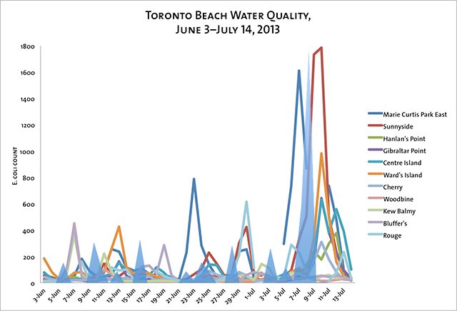
A quantification of this fecal flow is visible in the E. coli counts at Toronto’s 11 public beaches, collected and published by the City on a daily basis each summer. Using a standard determined by the province, the City considers water with fewer than 100 E. Coli per 100 mL to be safe for swimming.
Here’s what the season has looked like so far:

Click the image for a larger version.
The shaded blue peaks represent the precipitation the City received on a day-to-day basis, using data from Weather Underground. (The peaks are relative to each other but are not to scale with the E. coli counts, since rainfall quantity is measured in mm, not units of E. coli.)
And for reference, here is a map on which we plotted the city’s 11 beaches, four wastewaster treatment facilities, and three big river mouths: